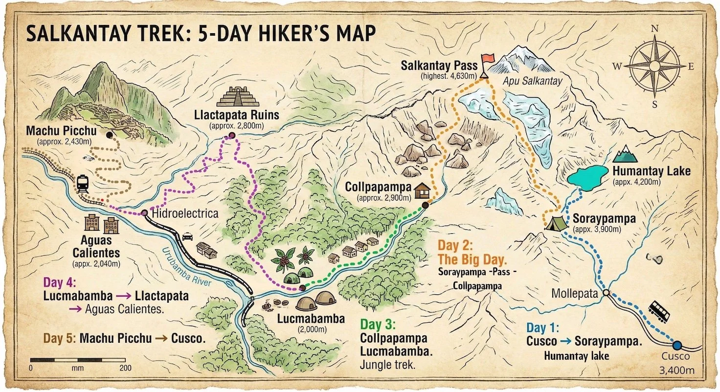
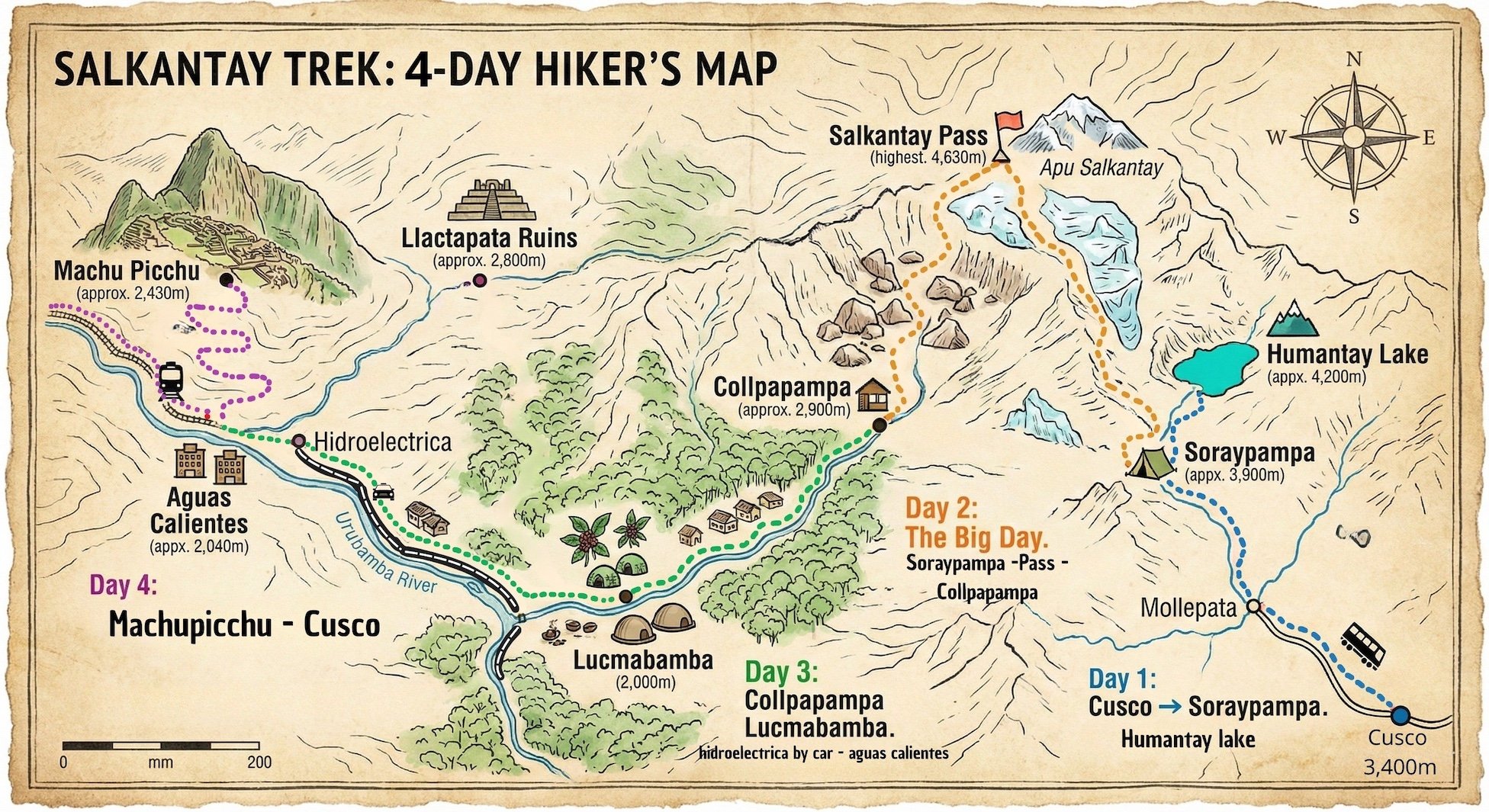
The Classic 5-Day Salkantay Trek
The most popular route. 74km of mountains, jungle, and history.
-
Cusco → Mollepata → Soraypampa
You start early from Cusco, driving to the trailhead at Challacancha or Soraypampa. The hike today is a steady uphill warm-up to the base of the glaciers. In the afternoon, most hikers do the side trip to Humantay Lake, a stunning turquoise lagoon at the base of the mountain.
Hiking Distance: 13 km (8 miles)
Starting Elevation: 3,800 m (12,467 ft)
Campsite Elevation: 3,900 m (12,795 ft) - Cold!
Difficulty: Moderate
Highlights: Humantay Lake, first views of Salkantay Mountain.
-
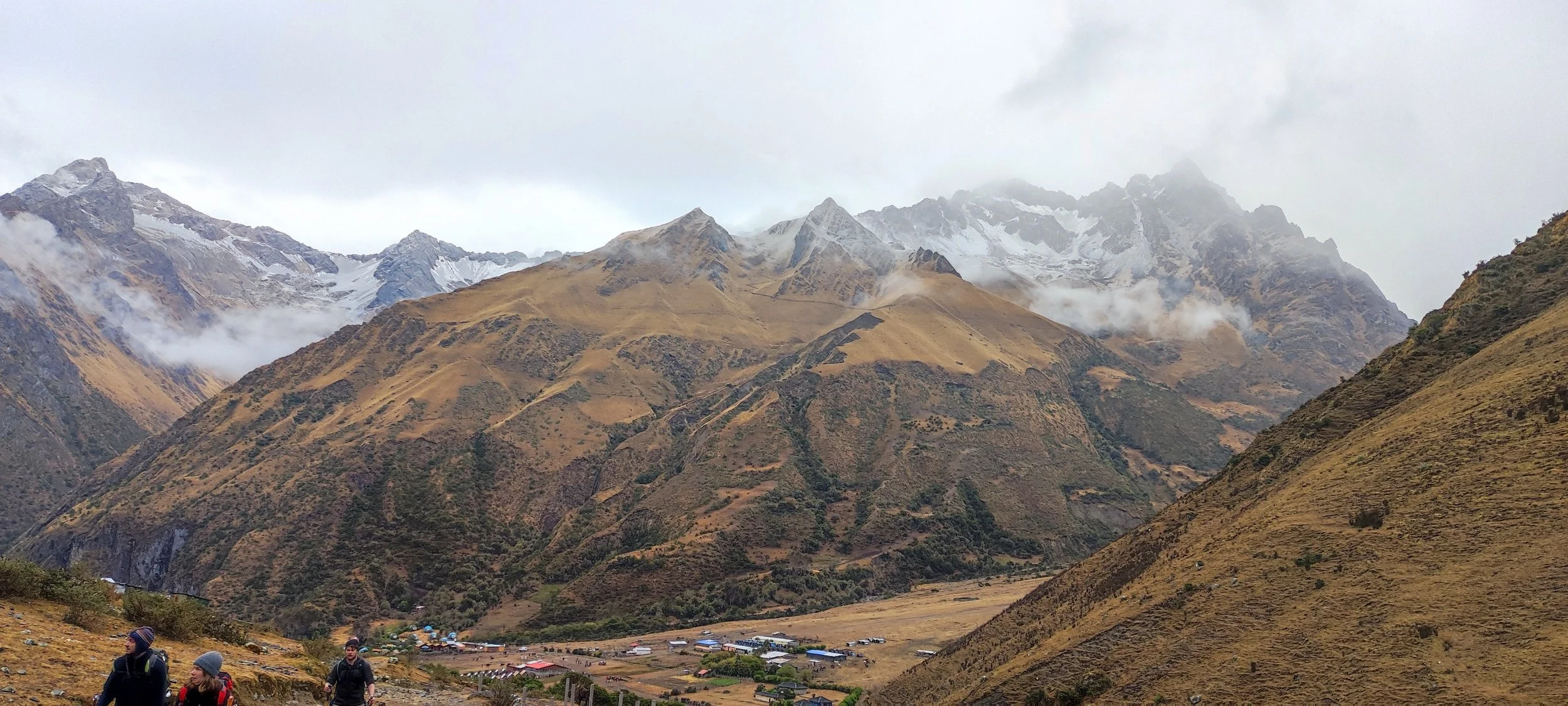
Soraypampa → Salkantay Pass → Collpapampa
This is the "Big Day." You will wake up before dawn to conquer the Salkantay Pass (4,630m). It is a steep, breathless ascent. After celebrating at the top, you face a long, steep 4-5 hour descent into the cloud forest. You will finish the day exhausted, muddy, and ready for comfort.
Hiking Distance: 22 km (13.6 miles) — Longest day of the trek.
Max Elevation: 4,630 m (15,190 ft) — Salkantay Pass.
Campsite Elevation: 2,900 m (9,514 ft) — Collpapampa.
Difficulty: Challenging / Hard.
Why Stop Here:
Recovery at Collpapampa Lodge: You have just dropped 1,700m in elevation. The air is thicker and warmer here. We provide Gas-Heated Hot Showers and hearty meals to bring you back to life.
-
Collpapampa → Lucmabamba
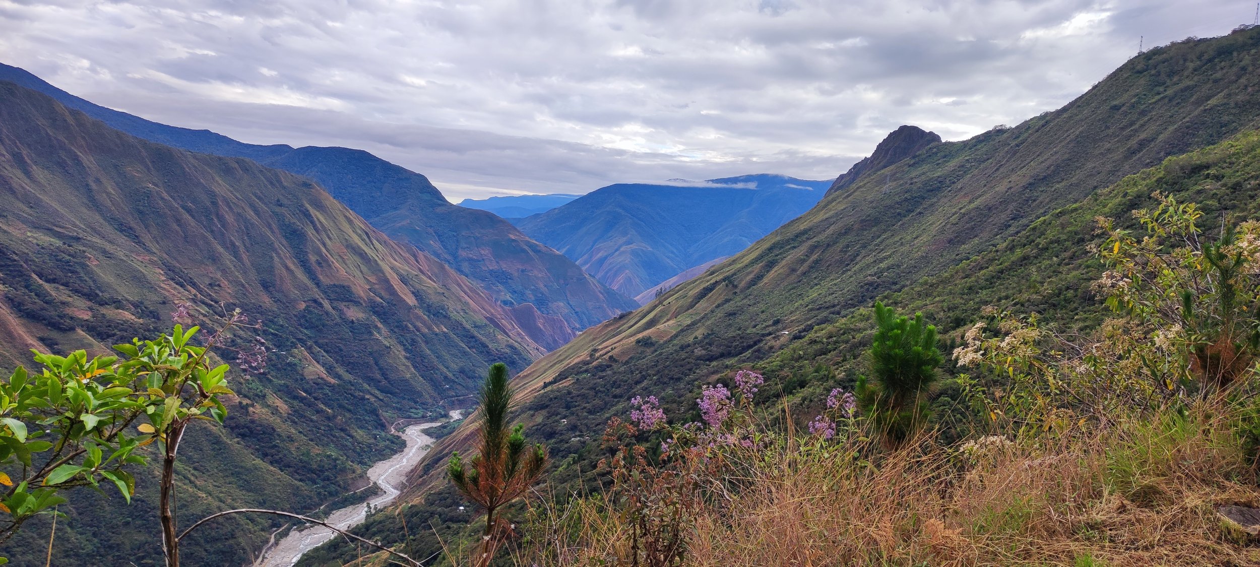
A complete change of scenery. Today is a "nature walk" through the Santa Teresa Valley. The trail follows the river through the high jungle (Ceja de Selva). You will pass waterfalls, wild orchids, and fruit plantations. The climate is tropical and humid.
Hiking Distance: 16 km (10 miles)
Starting Elevation: 2,900 m (Collpapampa)
Campsite Elevation: 2,000 m (6,561 ft) — Lucmabamba.
Difficulty: Moderate (mostly flat/downhill).
Highlights: Waterfalls, wild strawberries, warmer weather.
Why Stop Here:
Lucmabamba Coffee Experience: Don't just walk past the coffee farms—taste them! Stop at our family farm for a Farm-to-Cup Coffee Tour and a fresh lunch before relaxing for the evening.
-
Lucmabamba → Llactapata → Aguas Calientes
Most hikers start the day with a steep 3-hour climb up to the Llactapata Ruins, an ancient Incan lookout point. From here, you get the first distant view of Machu Picchu across the valley. You then descend to the Hydroelectric station and walk along the train tracks to Aguas Calientes.
Hiking Distance: 19 km (11.8 miles)
Max Elevation: 2,800 m (Llactapata Pass).
Destination Elevation: 2,040 m (Aguas Calientes).
Difficulty: Moderate to Challenging (The morning climb is steep).
Highlights: Llactapata Ruins, walking the train tracks.
-
Aguas Calientes → Machu Picchu → Cusco
The grand finale. You will take the early bus or hike up the stairs to the Machu Picchu citadel for a guided tour.
Activity: Tour of Machu Picchu.
Max Elevation: 2,430 m (Machu Picchu).
Difficulty: Easy (if taking the bus) / Moderate (if hiking up).
Return: Train to Ollantaytambo → Bus to Cusco.
The Express 4-Day Salkantay Trek
A faster-paced adventure for fit hikers who want to see it all in less time.
-
Cusco → Soraypampa (Humantay Lake)
You leave Cusco early (around 4:30 AM) and drive to the trailhead. Then start the hike in Challacancha or Soraypampa. After Breakfast, you hike to Soraypampa. In the afternoon, you tackle the steep climb to Humantay Lake for acclimatization before returning to camp to sleep under the stars.
Hiking Distance: 13 km (8 miles)
Starting Elevation: 3,800 m (12,467 ft)
Campsite Elevation: 3,900 m (12,795 ft)
Difficulty: Moderate
Highlights: Humantay Lake, Salkantay Mountain views.
-
Soraypampa → Salkantay Pass → Collpapampa
The hardest day remains the same. You conquer the massive Salkantay Pass (4,630m) and then descend 1,700 meters into the high jungle. By the time you reach Collpapampa, your legs will be shaking.
Hiking Distance: 22 km (13.6 miles) — The "gringo killer"
Max Elevation: 4,630 m (15,190 ft)
Campsite Elevation: 2,900 m (9,514 ft) — Collpapampa.
Difficulty: Hard / Challenging.
Where to Stay:
Recover at Salkantay lodge collpapampa: This is the end of the line for Day 2. You need a Gas-Heated Hot Shower and a real bed tonight. We are located right at the trail's transition point.
-
Collpapampa → Lucmabamba → Hydroelectric → Aguas Calientes
This is the key difference in the 4-Day trek. You combine the "Jungle Day" and the "Train Tracks" into one massive push.
Morning: Hike 5 hours through the lush Santa Teresa Valley to Lucmabamba.
Midday (CRITICAL STOP): Lunch & Rest.
Afternoon: Take local transport to Hydroelectric, then hike (or take the train) to Aguas Calientes.
Hiking Distance: ~16 km hiking + Car Transfer + 10 km walking (along tracks).
Starting Elevation: 2,900 m
Lunch Elevation: 2,000 m (Lucmabamba)
Destination Elevation: 2,040 m (Aguas Calientes)
Why Stop Here:
Refuel at Samir lodge Coffee Farm: Since this day is so long, you must break it up. Stop at our farm in Lucmabamba for a "Power Lunch" and Organic Coffee. It gives you the energy boost you need to finish the journey to Aguas Calientes.
-
Aguas Calientes → Machu Picchu → Cusco
You wake up early to catch the bus or hike up to Machu Picchu. After your tour, you return to Aguas Calientes for the train back to Cusco.
Activity: Tour of Machu Picchu.
Max Elevation: 2,430 m.
Difficulty: Easy to Moderate.
Return: Train to Ollantaytambo → Bus to Cusco.
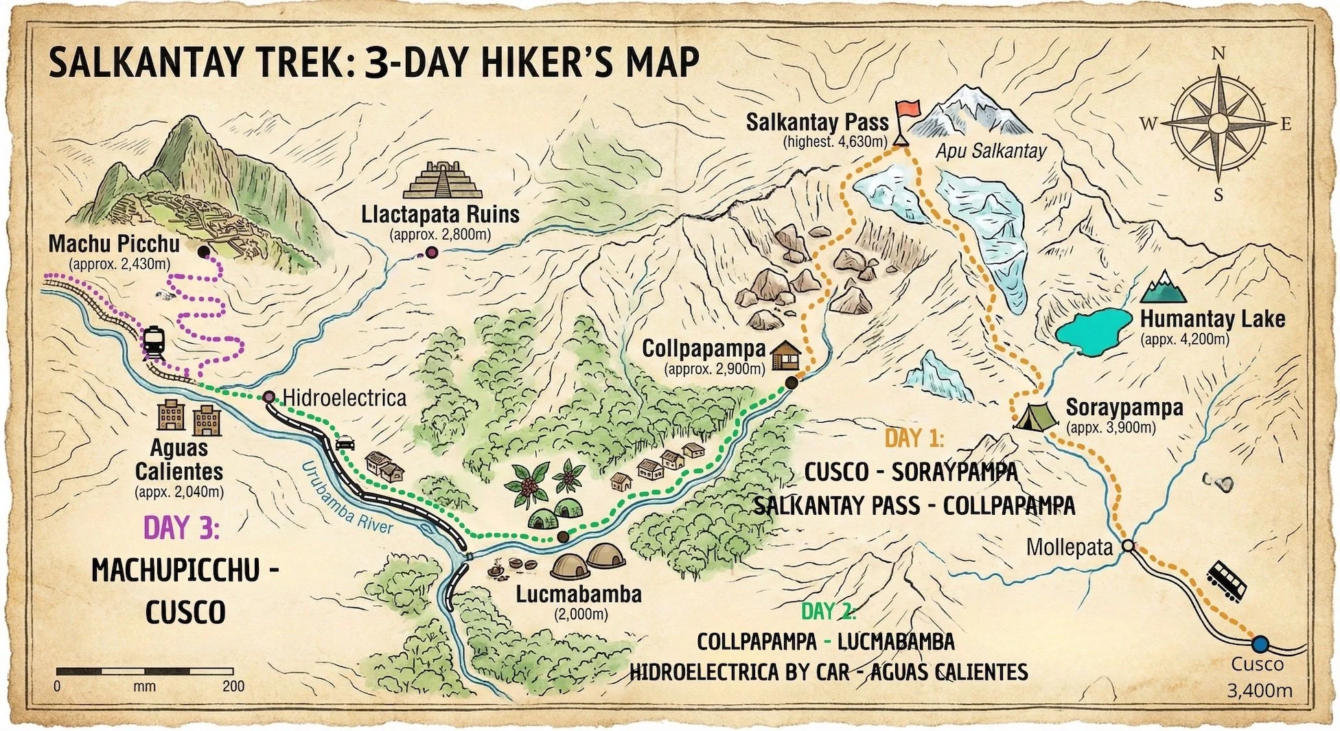
The 3-Day Salkantay Challenge
For fit hikers only. A fast-paced endurance test.
-
Soraypampa → Salkantay Pass → Collpapampa
You leave Cusco at 4:00 AM and drive directly to Soraypampa. You skip the acclimatization night and start hiking immediately toward the Salkantay Pass. After conquering the 4,630m summit, you endure a long, steep descent into the cloud forest.
Hiking Distance: 22 km (13.6 miles)
Hiking Time: 9–11 Hours (A very long day).
Max Elevation: 4,630 m (15,190 ft).
End Point: Collpapampa (2,900 m).
Difficulty: Very Hard.
Why You Need This Lodge:
The Recovery Zone: By the time you reach Collpapampa, you will have been awake for 16 hours and hiked for 10. Do not camp. You need our Hot Gas Showers, a real mattress, and a high-calorie dinner to recover for tomorrow.
-
Collpapampa → Lucmabamba → Hydroelectric → Aguas Calientes
After a heavy breakfast at the lodge, you hike through the Santa Teresa Valley. The pace is fast. You arrive in Lucmabamba around midday. From there, most 3-day trekkers take a local van transport to the Hydroelectric station, then walk the final 10km along the train tracks to Aguas Calientes.
Hiking Distance: 16 km (Hiking) + Car Transfer + 10 km (Walking tracks).
Starting Elevation: 2,900 m (Collpapampa).
Lunch Stop: Lucmabamba (2,000 m).
Difficulty: Moderate / Long.
Why Stop Here:
The Essential Pit-Stop: You cannot make it to Aguas Calientes on an empty stomach. Stop at our Lucmabamba Coffee Farm for a quick "Power Lunch" and Coffee. We can also help arrange the local transport to Hydroelectric from our door.
-
Aguas Calientes → Machu Picchu → Cusco
An early start to catch the bus or hike up to the citadel. You tour the ruins in the morning and take the train back to Cusco in the afternoon.
Activity: Tour of Machu Picchu.
Max Elevation: 2,430 m.
Difficulty: Easy.